
Over half of people of color in Wisconsin cities live within one mile of a facility that emits Hazardous Air Pollution.
Air pollution is a leading environmental threat to public health in the United States. The Clean Air Act requires the Environmental Protection Agency to establish air quality standards for just six common air pollutants (referred to as “criteria air pollutants”): ozone, particulate matter, carbon monoxide, lead, sulfur dioxide, and nitrogen dioxide. As such, these are the best known and most studied air pollutants.
Other air pollutants that are harmful to health are collectively referred to as “hazardous air pollutants” (HAPs) or “air toxics.” Although there are no air quality standards for these pollutants, the Clean Air Act currently regulates the emissions of 188 HAPs; Wisconsin’s air toxics rule goes further than the federal rule and regulates emissions of close to 500 HAPs. These HAPS cause cancer, birth defects, respiratory problems, and other health effects. Examples include benzene, formaldehyde, dioxin, and mercury.
To better understand HAP pollution in Wisconsin, we used data from the Environmental Protection Agency’s most recent Air Toxics Screening Assessment. This assessment models concentrations of HAPs in the air and estimates subsequent health risks at the census tract level based on information about emissions sources.
Based on this data, Wisconsin has lower levels of HAP air pollution than the United States as a whole. Wisconsin’s statewide average noncancer respiratory hazard index (where 0 represents no health risk and a value of 1 represents likely health consequences from exposure) from the dataset was 0.2 compared to the national average of 0.3. The statewide additional cancer risk from HAPs was 18 per million residents compared to the national average of over 25 per million.
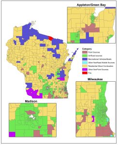
Compared to the United States as a whole, in Wisconsin relatively less HAP pollution comes from point sources (e.g., power plants and industrial facilities) and relatively more comes from transportation (e.g., cars and trucks) and nonpoint sources (e.g., residential wood-burning fireplaces and other dispersed emissions sources).
In urban areas of the state, on road transportation is the largest single source category of carcinogenic HAP emissions. In most other areas, residential wood burning (e.g., wood stoves, firepits) is the largest source of carcinogenic HAP emissions (Fig. 1).
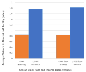
As with most environmental impacts, more vulnerable communities experience worse impacts from HAP exposure than less vulnerable communities. Higher income and/or non-minority communities live over twice as far away from point sources of HAP emissions (Fig. 2).
Over half of the minority population in urban areas of the state live within one mile of a HAP-emitting facility, compared to only a third of the non-minority population. This is important because compared to criteria air pollutants, HAP impacts tend to be more localized near sources, with concentrations dropping off quickly farther away.
Similarly, health risks from HAPs increase with larger proportions of minority residents in a census tract. This trend holds for all major categories of emissions sources, and is most pronounced for on-road transportation sources.
